A few words about the tram system
It is no secret that the tram is a very versatile type of transportation which can perform the function of ordinary urban transport and be a trunk mover of a significant amount of passengers. Moreover, these functions can be easily combined even within a single line to create more efficient throughput. I am happy to state that Rīga has preserved its tram network quite well, but unfortunately, over the past 30 years, this network has been not extended at all. Thus, the real potential of the Latvian capital’s tram network has not yet been discovered, which is very disappointing.
If we take a look at the existing infrastructure, it becomes clear that almost nothing must be changed here but can be added – I mean the extensions reach some district of the city or nearest suburban areas, as well as a few extensions to the stations of the commuter rail network. It will let the tram system sparkle in completely different colours.
So what can be improved?
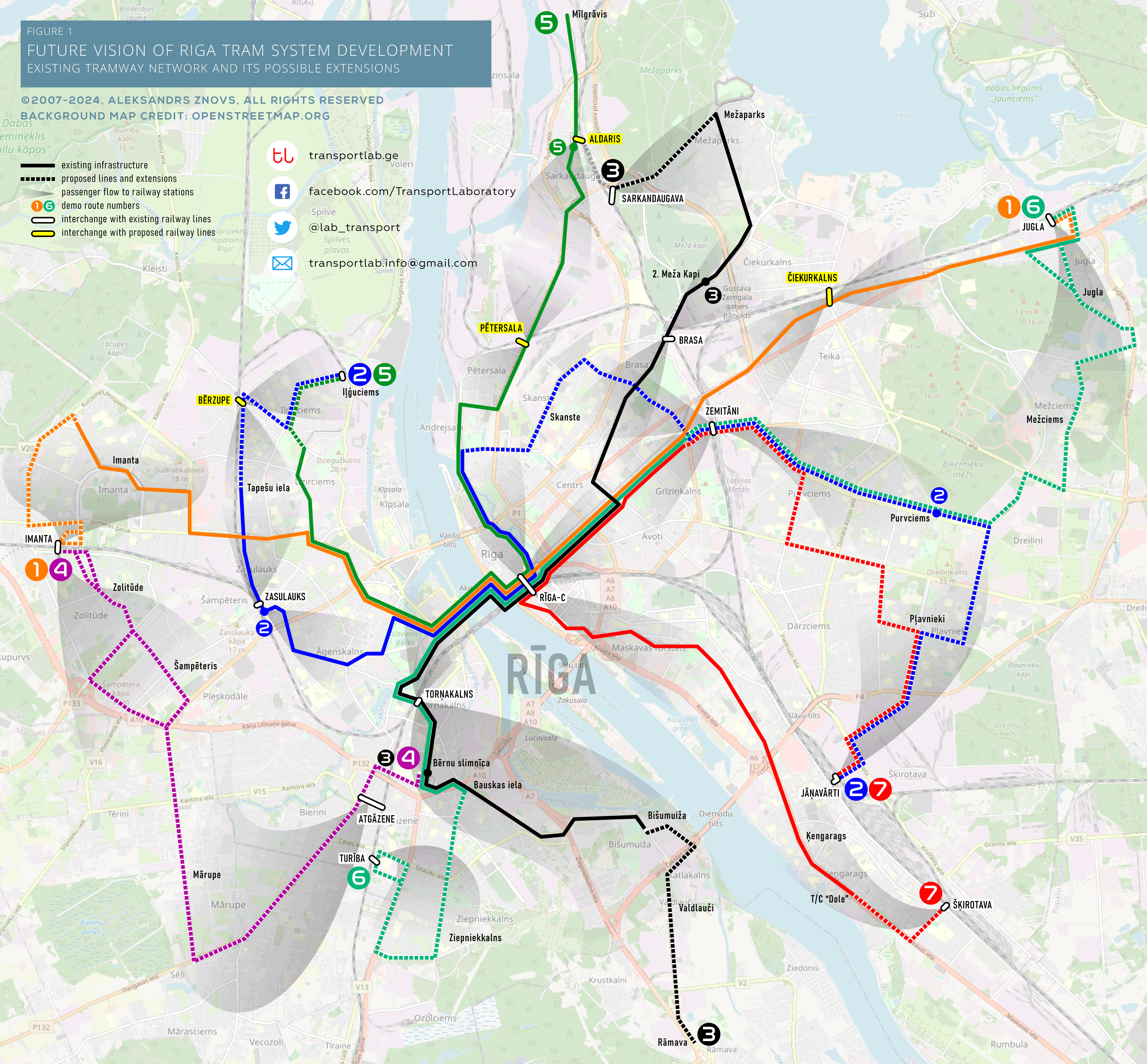
I hope it is not necessary to explain that heavy rail transport has a much greater capacity, which is very useful during the peak hour. This is why my vision is based on the goal of transferring passengers from municipal transport to commuter rail, where possible and appropriate. Let’s look at Figure 1 and start from Route 1. This is an already existing route that connects the city district of Imanta, passing the city centre and terminating at Jugla District in the east of the city. From both ends, the route can be slightly extended to the nearby railway stations. This will help transfer more passengers to commuter trains.
Further, we can combine the existing routes 10 and 11 (let’s give them demo Route 3). Well, firstly, the trams of this route will no longer have final stops in the centre, which will help to unload the infrastructure of the crowded city centre. Secondly, it is very expedient to extend this line from Mežaparks District to Sarkandaugava Station. In the southeast, from Bišumuiža District, the route could be extended to the rapidly growing Ramava residential area. The new combined route will become more useful. In addition, shortened route from the Bērnu slimnīca to 2. Meža kapi can be added. To make the transfer to Route 5 more convenient, the line can be additionally extended to Aldaris Station.
Route 5 will remain practically unchanged with only one difference – in the Ilģuciems District it can be laid to Dzirciema St., where it can serve more passengers. Thus, it will be possible to significantly relieve the corresponding bus and trolleybus routes. During the off-peak hours, some trams may terminate near the proposed new Aldaris Station.
Route 7 includes an existing route with the same number. It connects the densely populated Kengarags District and the city centre. From the Dole Shopping Mall, I advise extending it to the Šķirotava Station. From the centre the tram will go to Pērnavas St., Zemitāni Station, then through Purvciems and Pļavneiki districts, it will terminate at the Jāņavārti Station.
At the moment, Route 2 is relatively weakly used due to its route location. To revive it, I offer to extend it to the new terminus of Route 5, which will provide the residents of Iļģuciems easy access to commuter rail at Zasulauks Station and will unload local bus and trolleybus routes. From the centre, it could go further through the Skanste District to the Zemitāni Station, then through the northern part of the Purvciems District, the eastern part of Plavneki District the route can terminate at the Jāņavārti Station, where is the terminus of Route 7. In addition, shortened route from Purvciens to Zasulauks Sta. can be introduced.
To make the tram system brilliantly complete, more efficient and functional, all that remains is to add two more routes. One of these routes – Route 6 – will partially use the already existing segment of infrastructure from Bauskas St. to Pērnavas St. In the south of the capital, this route will pass through the densely populated Ziepniekkalns District and may reach the Turība Station. Thus, residents of Ziepniekkalns will have convenient access to the commuter rail, which will significantly relieve the city’s transport network. The eastern direction of the route will pass through Zemitāni Station, the northern part of Purvciems District, Mežciems District and could reach Jugla Station, where Route 1 has its terminus.
And the last one is Route 4. This route is going to be made from the scrap and it could connect Route 3 and Route 6 at Bērnu Slimnīca, pass through the suburban municipality of Mārupe, Šampēteris and Zolitūde districts and terminate at the Imanta Railway Station, where passengers can also change to Route 1. This route would help significantly relieve the city’s bus network and give residents of these areas a convenient opportunity to access commuter trains through Atgāzene and Imanta stations.
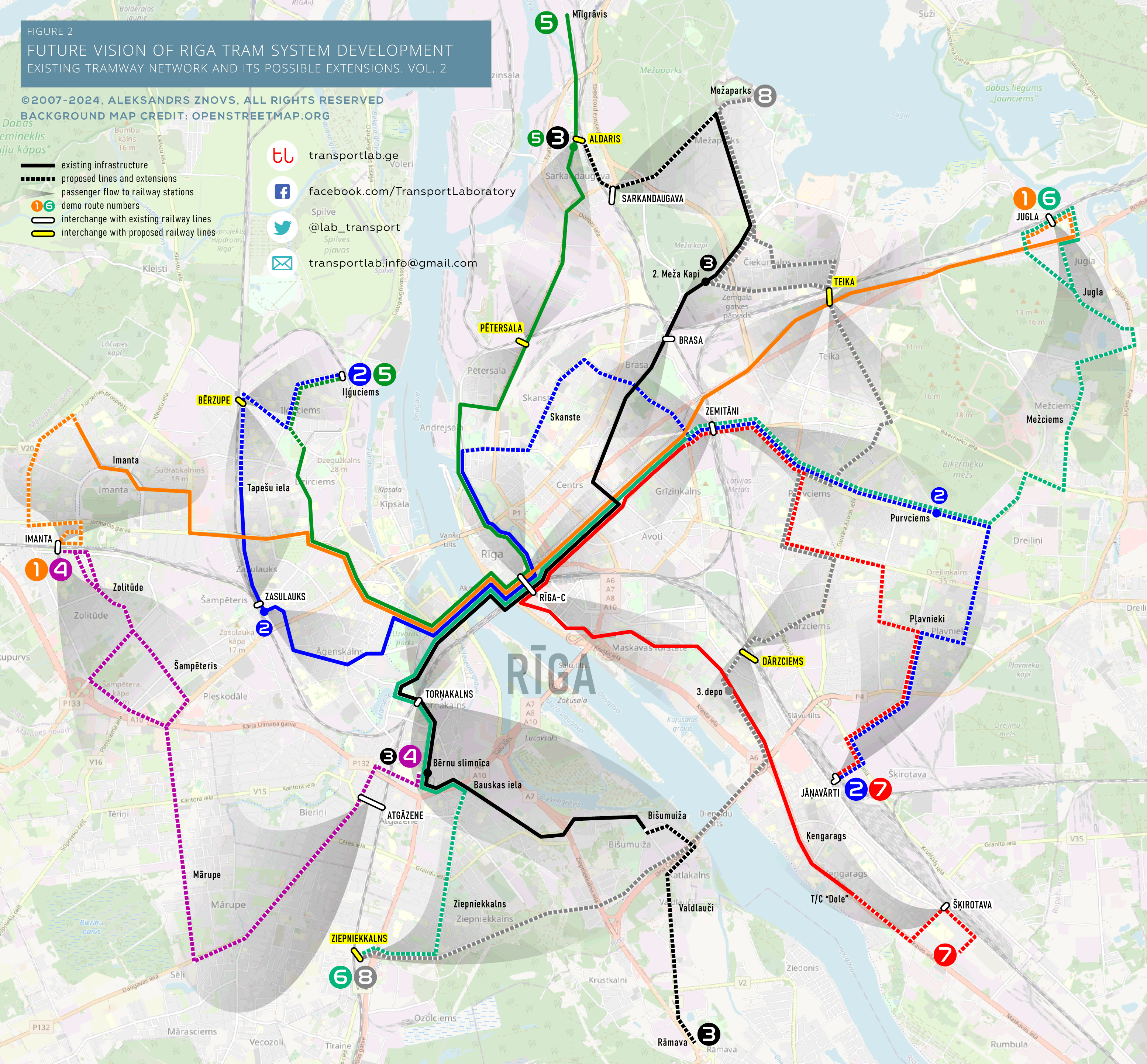
Optional Route 8
Right after the publication of this article, some fans of public transport expressed their opinion about the necessity to consider the connection of Purvciems and Pļavnieki with the Maskavas Forštate. Since this might be associated with significant costs, I initially didn’t even propose this option. However, I have marked this highly ambitious option on the map giving it demo number 8. The biggest problem is a crossing of the Daugava River on or along the Dienvidu tilts (Southern Bridge). If the construction of the bridge allows building tram tracks and trams can get on the bridge or exit it – this would be beautiful. Otherwise, the new tram bridge must be constructed instead. Secondly, to make the route a full-fledged peripheral one, two more tunnels must be built. One of them is under the railway connecting Reznas St. and Pildas St., where recently already proposed to build the Dārzciems Station. The second tunnel would pass under the railway line in the area of Džutas Street, where I also proposed to build Teika Station. Please note that in this version I slightly changed routes 1, 6, 7.
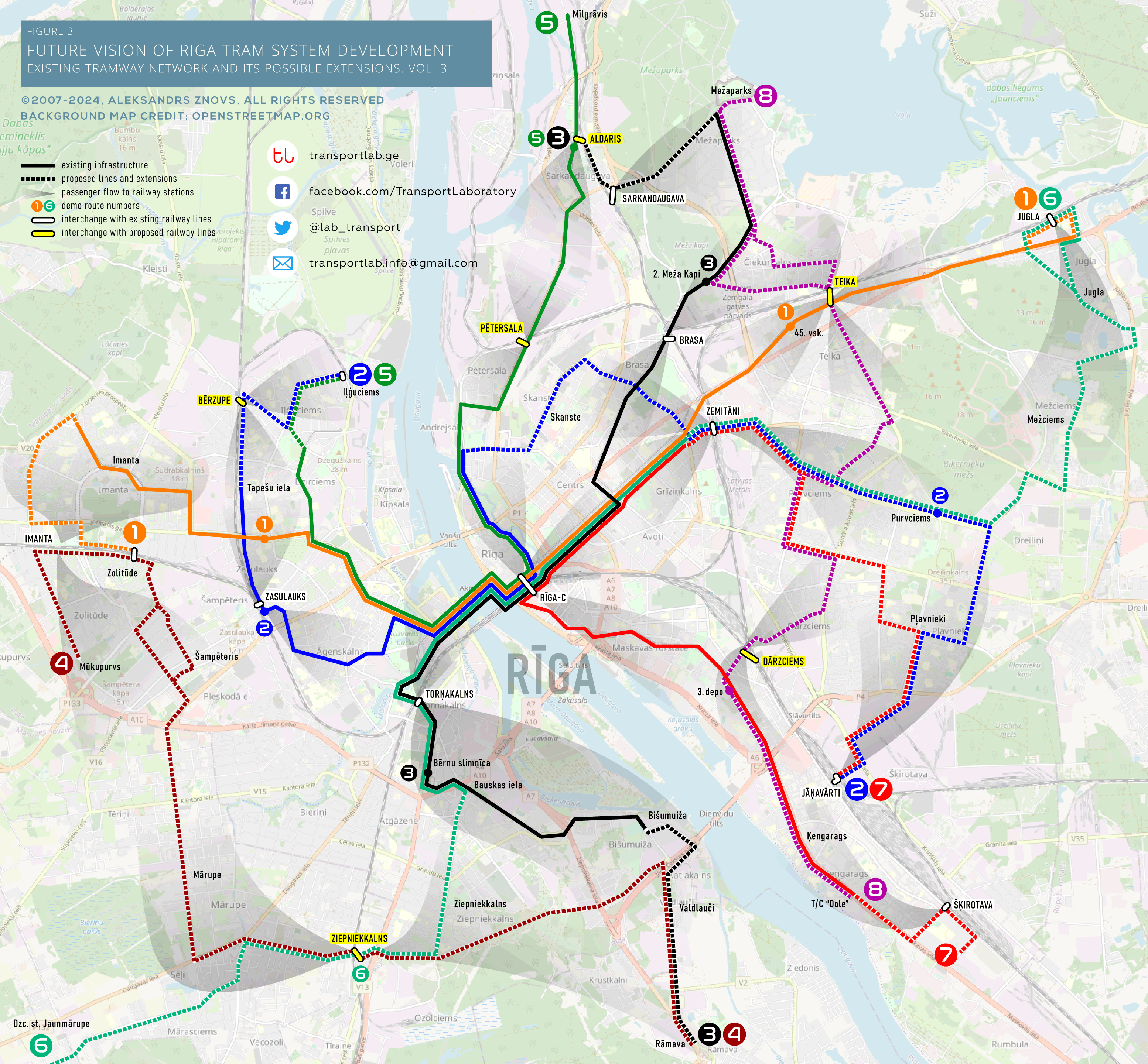
Of course, the plan is quite ambitious and can be put into practice for a long time, but it would greatly help to unload the streets of the city and improve the ecological situation. Besides, I note that we must take into account both the throughput of the streets and the state of the city’s infrastructure, so in reality the plan might look a little different. Though it is only a vision. Additionally, I made one more version avoiding passing the river at South Bridge (Dienvidu tilts). On Figure 4 you can see how this option would look like. Here proposed Route 8 would be much shorter and will join Route 7 till the Dole. Same here are some changes to Routes 4 and 6. Okay, that’s all for today.
I kindly ask you is to visit and like my page on Facebook where you can contact me in case of any question or claim mistakes found on the network maps. If it is more comfortable for you please follow me on Twitter just to be always informed about new uploads. Thanks.
Title image credit: Rīgas Dome