
Overture
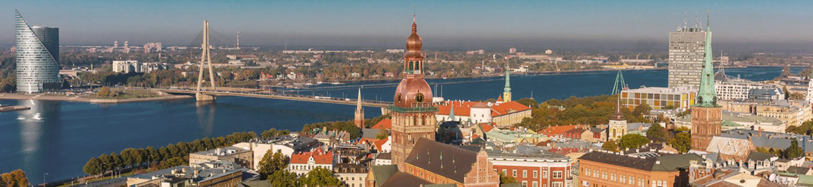
In the mid-70s, in rapidly growing City of Riga – the capital of the Latvian SSR (now the Republic of Latvia), the city authorities began planning the metro system, which, according to their plans, would consist of three intersecting lines connecting the main densely populated areas of the city with the centre.
Unfortunately, this project didn’t take place due to massive criticism the project authors faced from the local society, since there was no clear image how the underground works will be carried out and how this would affect the state of the historical architecture city centre. One more reason was the reluctance of citizens to allow an influx of labour from other union republics, which was a very acute issue in those years.
By the way, back in the 80s, some experts proposed the least costly and efficient alternative to the metro, which could use already existing railway infrastructure that runs through the entire city. Unfortunately, the city administration ignored this idea and continued to create new lines of road transport. All subsequent leaders of the city government continue the same tradition with passion. Regretfully, the same situation is still present nowadays.
So, for a while, let’s forget about the metro and focus on the idea of using the city’s existing rail infrastructure to create a network of rapid city rail transport. As in previous articles, I will deliberately not touch on scientific theses, counting residents and their daily routes, I won’t take a critical look at all kinds of obstacles and factors that may arise in the process of organizing transit. Let the specialists do this, especially since they receive a lot of money for this. 😉 Everything will be quite simple here, with a small degree of scepticism, according to the best traditions of maximalism, as it uses to be in fantasies. Let’s go!
What do we have?
Riga is located on the shores of the Gulf of Riga and precisely divided by the Daugava River. If you look at Figure 1 below, you will immediately notice the convenient location of the railway tracks. These are the main corridors intensively used by the passenger and freight carriers, freight routes, and industrial purpose tracks. Please click on image to enlarge and right-click for options:
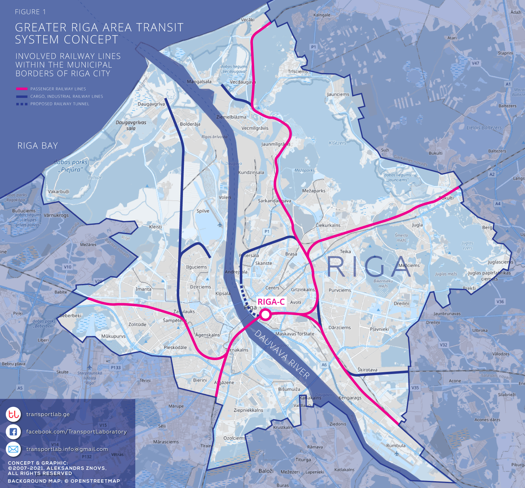
On Figure 1 all tracks which are already in use for passenger traffic and have fully functional stations are in pink colour. These lines can be first to begin the service. Thus, the next stage would be the construction of new stations within the city borders, which will increase the popularity of the transport network among the potential passengers. Parallelly it will be possible to begin the conversion of cargo railway lines and the construction of stations on these sections according to demand.
The next possible stage could be the constructing of a 3,5 km long tunnel to connect Andrejsala and the central railway station (Riga-C). It will form the circle line around the entire old town and a part of the historic centre. The location of street paths allows building the tunnel in a relatively shallow depth, right under city streets. The tunnel could begin somewhere next to Washington Square and end at Valmieras Street. Tunnel section would have three underground stations: Jūras Termināls (Ferry Terminal), Rīgas Pils (Riga Palace, at the old town) and Riga-C (Central railway station).
Urban, suburban or regional?
Having dealt with the territory of the city, let’s turn our attention to how far the trains could run. Should we follow the city borders or go further?
Let’s not forget that the capital of Latvia located in the very centre of the country and, as often happens, the bulk of the population tends to be distributed near large cities, and especially capitals. Riga has quite a big agglomeration including the satellite-city Jurmala. Other densely inhabited areas are at a relatively short distance from the capital. Furthermore, significant masses of suburban inhabitants take their daily trips to the workplaces located in Riga and back.
If we look at the geographical map, from the centre of Riga City till the Jelgava Central Station is up to 40 km, till Ogre – 33 km, till Saulkrasti – 47 km, and till Sigulda 53 km, till Tukums – 63 km. Thus, we expanded our city train network and turned it into a suburban train, or, more correctly, into regional. Let’s take a look at what we got:
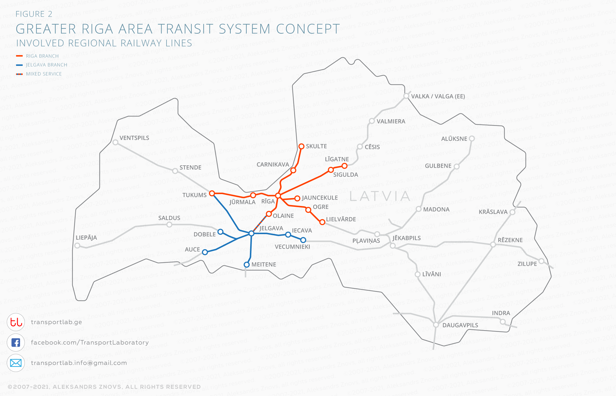
Except for the orange lines of our “newly invented” railway network, you can notice the branching of the blue lines – this is the already mentioned city of Jelgava with its suburbs, which is a notable railway junction. In my opinion, it would be advisable to organize the additional railway network branch in this part of the region adjacent to the capital with the centre in Jelgava. This transport system would work in coordination with the Riga transport system and will help to cover the entire central region of the country – the Greater Riga Region – from the sea coast above to the Lithuanian border below. Additionally, the network can also serve as a small city rail for this town.
Yes, of course, we all love beautiful pictures, so I have prepared more detailed, easily perceivable route schemes for your imagination.
At a glance
As the famous MAD TV star Crista Flanagan used to say: “We have the tuna, and we have the mayonnaise…” Let’s put all previous together and take a look at our Rapid Transit System, just like in reality.
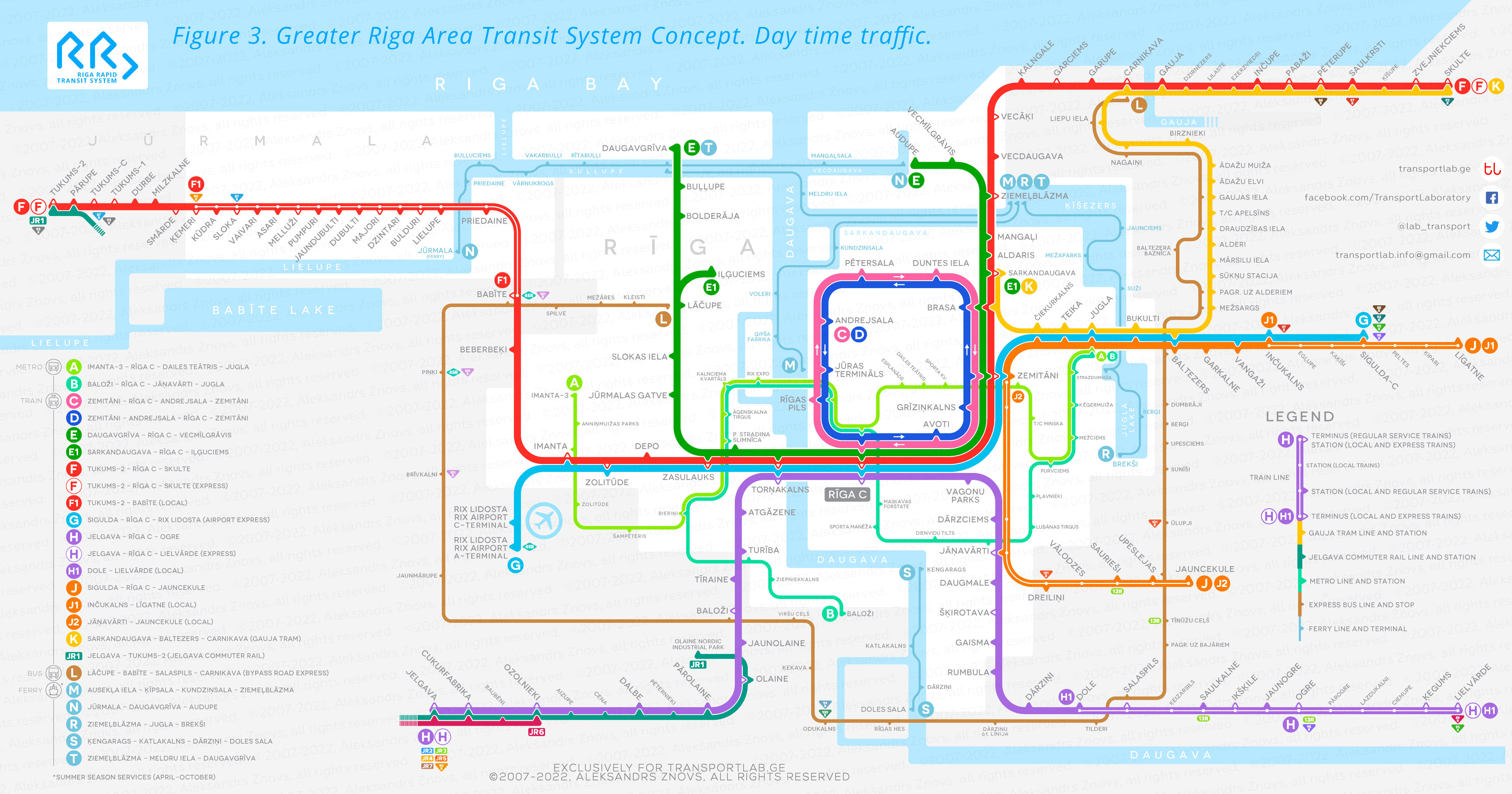
So, here we have the Line C / D – a circular line around the city centre with the most frequent train traffic. This line could be effective only after the 3,5 km long tunnel will be built between Andrejsala and the Central Railway Station.
Line E is a semi-circular route and it connects both sides of the city. There is single-track rail infrastructure for this line, but it is necessary to build several station platforms on the left bank of the river and two at the end of the route on the right side of the river. The line also includes a shortened E1 route to optimize traffic during the rush hours.
The longest and busiest line is supposed to be Line F, which will pass through Riga centre and connect the city of Tukums and Jurmala on the left coast of the Gulf of Riga with the inhabited areas of Carnikava, Saulkrasti and Skulte on the right side of the bay. The line assumes an express services and a local F1 route within the resort town of Jurmala.
The Riga International Airport and the centre of the capital would be connected by the Express Line G, which further extends till the Sigulda Town.
Line H would be able to connect the important Jelgava knot-station with Riga and the settlements of Ogre, Salaspils and Lielvarde. This line also has an express service option and a local H1 service.
Line J connect the Ligatne station, the town of Sigulda with Riga without passing through the centre. It goes to the suburban station Jauncekule. This line has two local services J1 and J2 for local needs.
All local services are unlikely to require multi-car trains, so they could be served by railcars or even light rail transport such as special tramways.
I deliberately skipped Line K, as it is a debatable option that requires significant investments for the construction of a light rail line from Baltezers Station through Adazi to Carnikava. This concept part requires detailed study and social debates. The route could be served by the LTR rolling stock – trams with a dual voltage system, which will be able to use both tram and heavy rail tracks. On the Carnikava-Skulte section, Line K would serve as a local train with all possible stops.
In the diagram, you also see Line L, which is not a railroad. This is an express bus service that follows the Riga Bypass Road and connects all lines of our train network through the peripheral stations.
The diagram also shows possible seasonal passenger ferry services (routes M, N, R, S, T), which can be perfectly integrated into this transport network. Due to the north-east location of the country, all water reservoir surfaces are covered with ice during the winter months, so the ferry service could serve from April till October.
Yes, we have not considered Lines A and B. This is an optional layout of metro lines that the city could build in the future if the population of the capital will grow significantly and the city will need additional passenger transport corridors. Both lines would be able to cover those areas that have a fairly dense population, such as Jugla, Mezciems, Purvciems, Plavnieki, Maskavas Forstate, Agenskalns and Imanta.
You are not alone in the night!
Every self-respecting capital should take care of its residents and offer a night traffic service. For the convenience of passengers, if possible, it is worth duplicating daily routes. Therefore, the lines CN, DN, FN, HN and LN almost are very similar to daytime lines C, D, F, H, L. Day routes differ from night ones by a smaller number of stops at night, the list of which, of course, can be changed according to the wishes of passengers. Night service might look like:
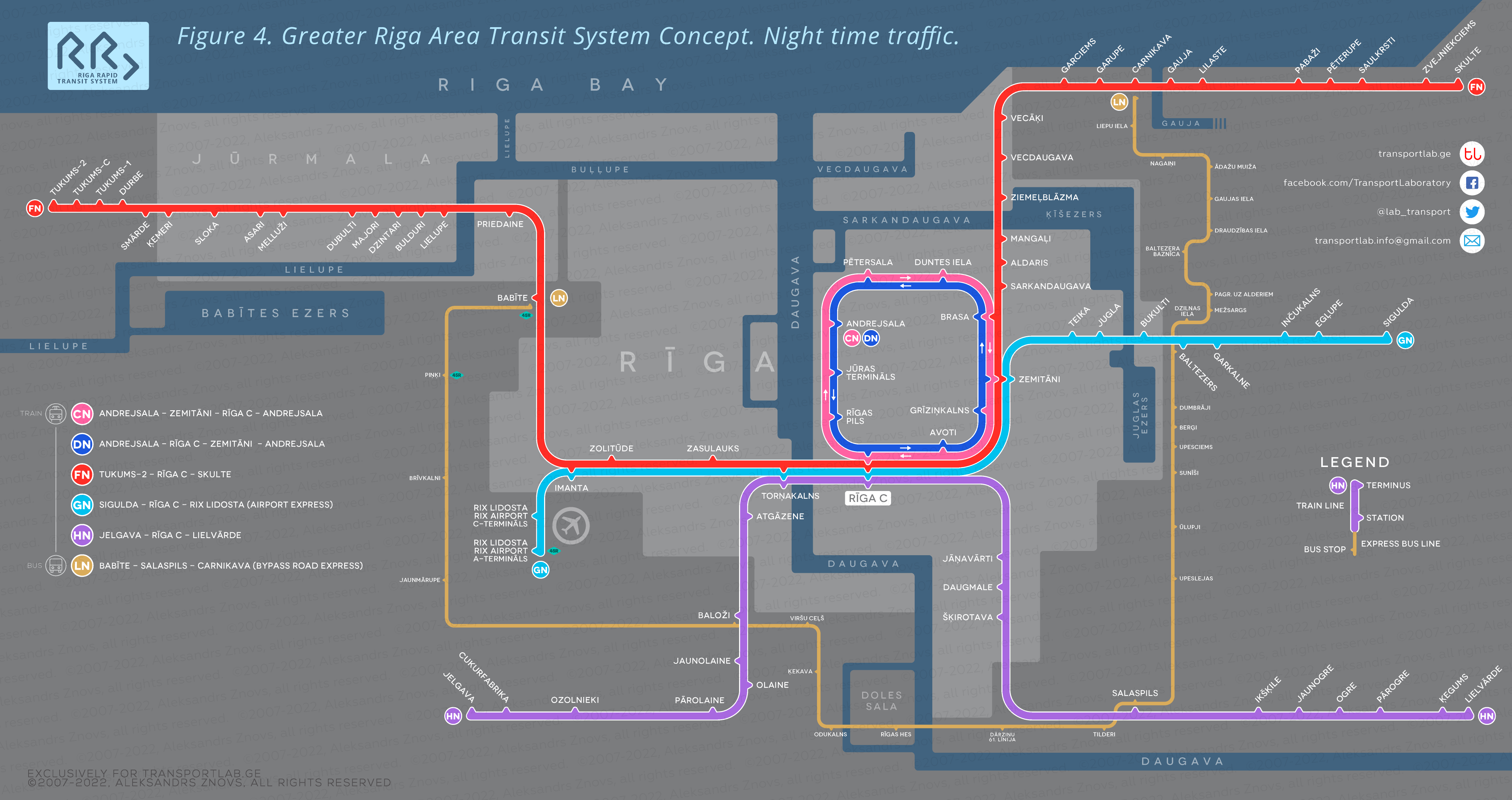
Lines A, B, C, E and J do not have night service and can easily be replaced by night buses, but in case of an appropriate flow of passengers, it will always be possible to organize a night rail service as well.
The junction station of Jelgava
The central railway station of Jelgava can become an important passenger hub in the southern part of central Latvia, complementing our entire transport network in the best way possible. At a relatively short distance from Jelgava, there are regional towns as Dobele, Auce, Iecava and Tukums. Besides, Jelgava itself is quite a large town and requires its solution for fast urban transport.
Thanks to the ramified railway structure, the city can be made more convenient for the townspeople. For three-line urban train service could be used small number one-carriage railcars passing through the central station and serving 18 stations.
Let’s call this our branch system Jelgava Commuter Rail. The whole service would look like this:
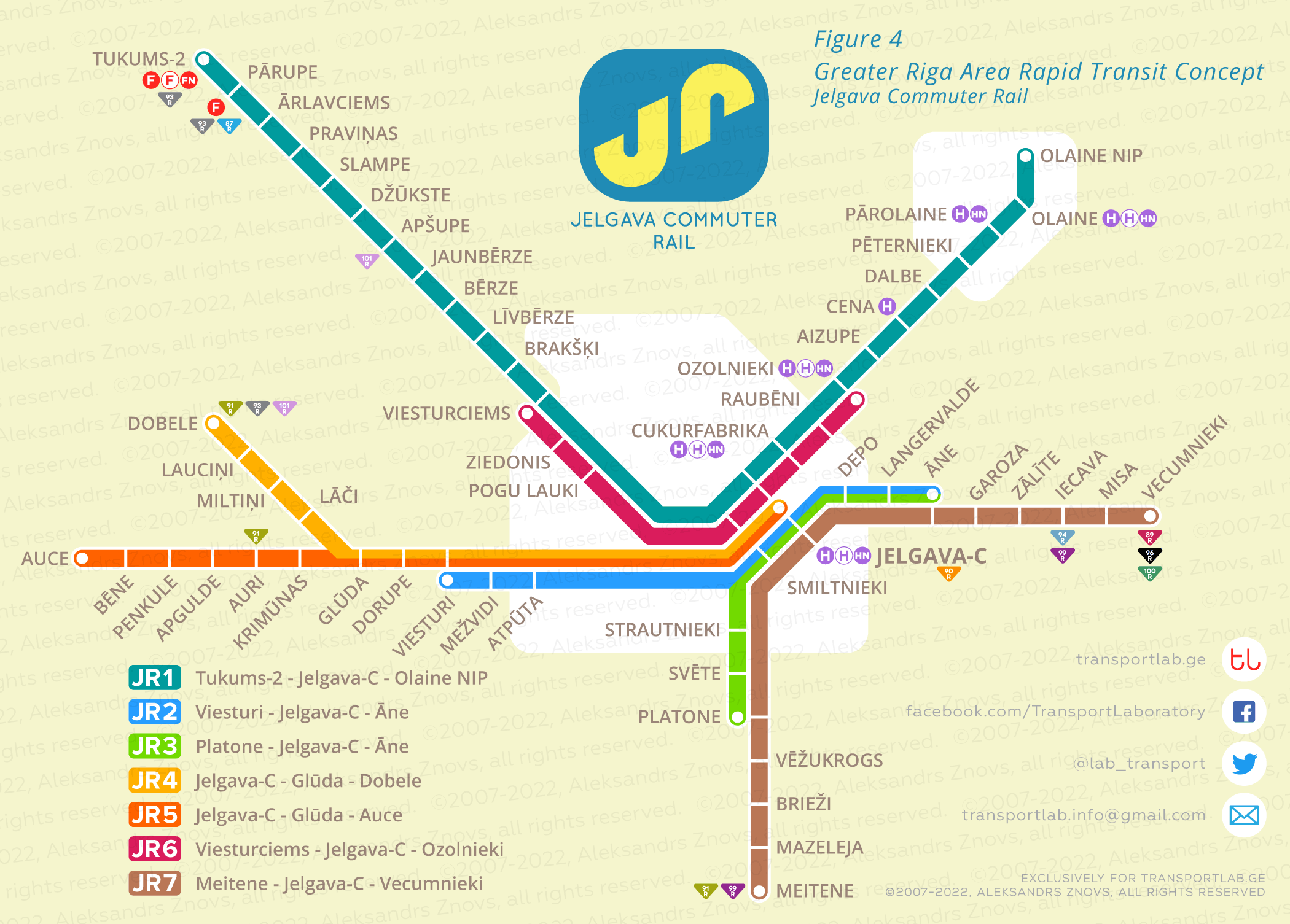
The routes JR2, JR3 and JR6 are urban, but all other train routes will serve regionally. Railcars of some lines can be coupled to optimize expenses.
That’s all for today
Well, we have figured out the first, mainly railway part of our fantasies about the bright transport future of the Greater Riga Area. In the next article, which I will share with you soon, we will end our conversation about how this transport system can be improved for its efficiency. We will talk about regional express bus services and local transportation within the region.

[…] posted two large, detailed and juicy illustrated articles about this concept, so you can find them here and here. Please consider to check these articles for better understanding the whole concept. […]
[…] I hope you remember the first part of my article where I considered the concept of the Greater Rīga Area railway network. The emphasis was on the rational use of the entire railway infrastructure. You can refresh the information here. […]
[…] broad-gauge lines. To read about the other Latvia’s broad-gauge rail networks you can here, here, here and here. Now let’s take a more detailed look at my vision. I overlaid all my […]